Difference between revisions of "Aguada Street"
Jump to navigation
Jump to search
(New page: {{Infobox road |marker_image= |road_name=Aguada Street |name_notes= |type= |route= |alternate_name= |maint= |length_mi= |length_round= |length_ref= |length_notes= |established= |decommissi...) |
m |
||
| Line 22: | Line 22: | ||
|mapcode= | |mapcode= | ||
}} | }} | ||
| − | '''Aguada Street''' was | + | '''Aguada Street''' was a delineated but unopened and unimproved street in the [[City of Pensacola]]. Laid out in the [[Water Front Tract]], "Aguada Street" was situated between [[Intendencia Street|Intendencia]] and [[Government Street]]s and was laid out from [[9th Avenue]] eastward until at least [[16th Avenue]]. For the duration of its existence, "Aguada Street" was unopened and lay nearly entirely underwater in [[Pensacola Bay]]. |
In [[1956]], the [[Pensacola City Council]] vacated Aguada Street in its entirety.<ref>Ordinance #14-56, ''An Ordinance to Close, Vacate, and Abandon Portions of Streets Lying in the Water Front Tract of the City of Pensacola, According to Map of Said City Copyrighted by Thomas C. Watson in 1906.''</ref> | In [[1956]], the [[Pensacola City Council]] vacated Aguada Street in its entirety.<ref>Ordinance #14-56, ''An Ordinance to Close, Vacate, and Abandon Portions of Streets Lying in the Water Front Tract of the City of Pensacola, According to Map of Said City Copyrighted by Thomas C. Watson in 1906.''</ref> | ||
Latest revision as of 22:40, 7 September 2009
| Aguada Street | |
| West end: | 9th Avenue |
|---|---|
| East end: | Pensacola Bay |
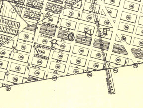
 Aguada Street as depicted on the Watson maps | |
Aguada Street was a delineated but unopened and unimproved street in the City of Pensacola. Laid out in the Water Front Tract, "Aguada Street" was situated between Intendencia and Government Streets and was laid out from 9th Avenue eastward until at least 16th Avenue. For the duration of its existence, "Aguada Street" was unopened and lay nearly entirely underwater in Pensacola Bay.
In 1956, the Pensacola City Council vacated Aguada Street in its entirety.[1]
References[edit]
- ↑ Ordinance #14-56, An Ordinance to Close, Vacate, and Abandon Portions of Streets Lying in the Water Front Tract of the City of Pensacola, According to Map of Said City Copyrighted by Thomas C. Watson in 1906.