Difference between revisions of "Chase Street"
m (image) |
m (added landmarks) |
||
| Line 50: | Line 50: | ||
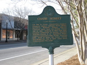
[[Image:ChaseStreet.jpg|thumb|left|A sign at acknowledging Chase Street's historical namesake]] | [[Image:ChaseStreet.jpg|thumb|left|A sign at acknowledging Chase Street's historical namesake]] | ||
Chase Street is named for Colonel [[William H. Chase]], the construction engineer for Forts [[Fort McRee|McRee]], [[Fort Barrancas|Barrancas]], [[Fort Redoubt|Redoubt]] and [[Fort Pickens|Pickens]] between 1828-1854, who captured the [[Navy Yard]] (ironically, some of the same fortresses he had engineered) for [[Confederate period|Confederate forces]] in January, 1861. | Chase Street is named for Colonel [[William H. Chase]], the construction engineer for Forts [[Fort McRee|McRee]], [[Fort Barrancas|Barrancas]], [[Fort Redoubt|Redoubt]] and [[Fort Pickens|Pickens]] between 1828-1854, who captured the [[Navy Yard]] (ironically, some of the same fortresses he had engineered) for [[Confederate period|Confederate forces]] in January, 1861. | ||
| + | |||
| + | ==Selected Landmarks== | ||
| + | *[[Rhodes Building]] (headquarters of [[Gulf Coast Community Bank]] and [[Ballinger Publishing]], among other tenants) | ||
| + | *[[St. Michael's Cemetery]] | ||
| + | *[[Pensacola Civic Center]] | ||
| + | *[[UWF Small Business Development Center]] | ||
| + | *The [[Jane C. Noonan Center]] at [[First Presbyterian Church]] (home of the [[Pensacola Children's Chorus]]) | ||
| + | *[[Residence Inn Marriott]] hotel | ||
| + | |||
{{road-stub}} | {{road-stub}} | ||
[[Category: Roads]] | [[Category: Roads]] | ||
Revision as of 14:50, 13 March 2007

| |
| Chase Street | |
| west end: | S Street |
|---|---|
| Major junctions: |
Palafox Street Tarragona Street Ninth Avenue Bayfront Parkway |
| east end: | Bayfront Parkway |
| Namesake: | William H. Chase |
|
<googlemap lat="30.414631" lon="-87.222519" type="map" zoom="13" width="288" height="288">
30.413854, -87.246208 30.413761, -87.243955
30.414048, -87.243901 30.413992, -87.242775
30.413706, -87.242764 30.413669, -87.241638
30.413197, -87.24152 30.412901, -87.234825
30.412836, -87.232722 30.412521, -87.226049 30.414705, -87.21312 30.415158, -87.211061 30.41538, -87.210009 30.415824, -87.206801 30.416, -87.20546 30.41675, -87.201201 30.416898, -87.200246 30.41674, -87.199849 </googlemap> | |
Chase Street is an east-west road in downtown Pensacola. Its westernmost terminus is at S Street, but is interrupted for two blocks between I and G Streets. It becomes one-way (east) at Devilliers Street. At Tarragona Street it briefly joins an I-110 overpass, then takes US 98 from Ninth Avenue to its eastern terminus at Bayfront Parkway.
Chase Street is named for Colonel William H. Chase, the construction engineer for Forts McRee, Barrancas, Redoubt and Pickens between 1828-1854, who captured the Navy Yard (ironically, some of the same fortresses he had engineered) for Confederate forces in January, 1861.
Selected Landmarks
- Rhodes Building (headquarters of Gulf Coast Community Bank and Ballinger Publishing, among other tenants)
- St. Michael's Cemetery
- Pensacola Civic Center
- UWF Small Business Development Center
- The Jane C. Noonan Center at First Presbyterian Church (home of the Pensacola Children's Chorus)
- Residence Inn Marriott hotel
