Difference between revisions of "Sanborn Maps"
(→1907) |
(→1907) |
||
| Line 211: | Line 211: | ||
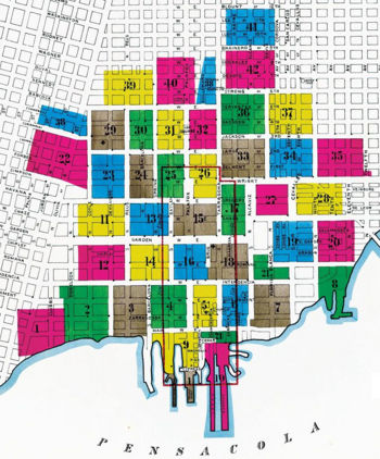
rect 423 352 468 448 [[Image:Sanborn1907-17.jpg|17]] | rect 423 352 468 448 [[Image:Sanborn1907-17.jpg|17]] | ||
rect 398 467 474 533 [[Image:Sanborn1907-18.jpg|18]] | rect 398 467 474 533 [[Image:Sanborn1907-18.jpg|18]] | ||
| + | rect 522 423 599 500 [[Image:Sanborn1907-19.jpg|19]] | ||
| + | rect 607 422 678 499 [[Image:Sanborn1907-20.jpg|20]] | ||
| + | poly 484 486 485 534 552 534 551 511 512 511 512 486 [[Image:Sanborn1907-21.jpg|21]] | ||
| + | poly 68 246 49 326 118 342 166 361 165 267 147 268 [[Image:Sanborn1907-22.jpg|22]] | ||
| + | rect 175 294 236 378 [[Image:Sanborn1907-23.jpg|23]] | ||
| + | rect 248 295 293 378 [[Image:Sanborn1907-24.jpg|24]] | ||
| + | rect 299 293 352 377 [[Image:Sanborn1907-25.jpg|25]] | ||
| + | rect 361 294 413 377 [[Image:Sanborn1907-26.jpg|26]] | ||
| + | rect 487 351 551 411 [[Image:Sanborn1907-27.jpg|27]] | ||
| + | rect 565 350 655 409 [[Image:Sanborn1907-28.jpg|28]] | ||
| + | rect 173 210 237 286 [[Image:Sanborn1907-29.jpg|29]] | ||
| + | rect 246 210 292 286 [[Image:Sanborn1907-30.jpg|30]] | ||
| + | rect 300 209 350 285 [[Image:Sanborn1907-31.jpg|31]] | ||
| + | rect 362 209 412 283 [[Image:Sanborn1907-32.jpg|32]] | ||
| + | rect 423 265 507 338 [[Image:Sanborn1907-33.jpg|33]] | ||
| + | rect 515 265 598 337 [[Image:Sanborn1907-34.jpg|34]] | ||
| + | rect 606 265 711 335 [[Image:Sanborn1907-35.jpg|35]] | ||
| + | rect 422 179 506 256 [[Image:Sanborn1907-36.jpg|36]] | ||
| + | rect 515 179 597 254 [[Image:Sanborn1907-37.jpg|37]] | ||
| + | poly 80 201 71 235 151 259 164 259 163 220 [[Image:Sanborn1907-38.jpg|38]] | ||
| + | rect 197 135 292 199 [[Image:Sanborn1907-39.jpg|39]] | ||
| + | rect 298 110 372 196 [[Image:Sanborn1907-40.jpg|40]] | ||
| + | poly 411 109 413 197 373 198 391 107 [[Image:Sanborn1907-38.jpg|38]] | ||
| + | rect 432 17 525 85 [[Image:Sanborn1907-41.jpg|41]] | ||
| + | rect 430 96 526 168 [[Image:Sanborn1907-42.jpg|42]] | ||
| + | |||
desc bottom-left | desc bottom-left | ||
Latest revision as of 03:48, 31 March 2009
The Sanborn Maps were a series of maps of urbanized areas created by the Sanborn Map Company in the late-nineteenth and early-twentieth centuries. They were used primarily by fire insurance agents to determine the degree of damage to a property and show accurate information to help them determine risks and establish premiums. The maps also described the status of local fire departments, water facilities, sprinklers, hydrants, cisterns, and alarm boxes as well as firewalls, windows, doors, elevators and chimneys and roof types. Because of their thoroughness and attention to detail, the maps have been praised by modern historians for providing "a guide to American urbanization that is unrivaled by other cartography and, for that matter, by few documentary resources of any kind."[1]
Contents
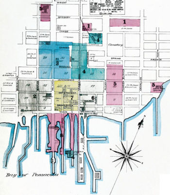
1884[edit]
The September 1884 map gives the following information about Pensacola:
- Population, 10,000. Prevailing Winds S.W. in Summer, N. in Winter.
- 2 Steam Fire Engines, 1 Hook & Ladder Co. 2000 Ft. of Hose, One Hundred & Fifty Firemen, Volunteer.
- Water Facilities, Bay, Streams, Cisterns & Private Tanks.
Notes[edit]
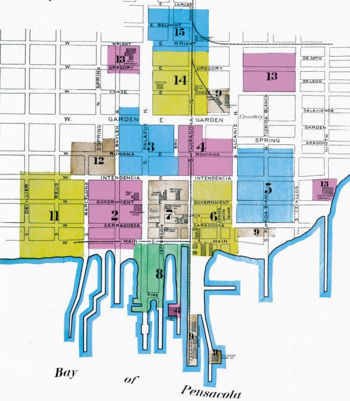
1892[edit]
The January 1882 map gives the following information about Pensacola:
- Population 15000.
- Prevailing Winds, S.W. in Summer, N. in Winter.
- Water Facilities
- Gravity System. 2 Deane Pumps. Independent pumps boilers and engine, Stand Pipe 137' high, 20' Diam. cap'y, 325000 Galls. Water can be pumped direct to mains. Cap'y of engines 2 Million Galls. per diem.
- 11 Miles of W. Pipes. Principal Main 14" Diam. 120 Hyd'ts.
- Fire Department
- Volunteer 225 Men. 6 Independent Hose Carts. 1 Steam Fire Engine. 1 Hook & Ladder Truck. 3000 ft. of Hose. Electric Fire Alarm System. 27 boxes.
Notes[edit]
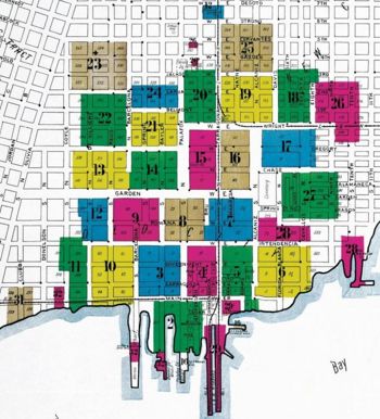
1903[edit]
The May 1903 map gives the following information about Pensacola:
- Population 22,000
- Prevailing Winds, S.W. in Summer, N. in Winter
- Water Facilities Pensacola Water Co. Gravity and direct pressure system. Water supply from 14-4" and 4-6" driven wells, capacity 9000 galls. each per hour. 20 Miles of water pipes, 6", 12" & 14" diam. 193 Double hydrants. Gravity pressure 80 lbs. direct pressure 150 lbs. per sq. inch.
- Water pumped to iron stand pipe capacity 325,000 galls. 137 ft high. by two Deane duplex pumps, cap'y 2 million galls each per 24 hours.
- Two storage reservoirs at pumping station, capacity 300,000 galls. each.
- Fire Department, Paid. 28 Men. Gamewell fire alarm system, 34 boxes.
- Four hose carts. 750 ft 2½" hose to each.
- One hook & ladder truck.
- One 3d class Silsby steam fire engine.
- 3500 ft. 2½" hose in good condition.
- Grades nearly level throughout town.
Notes[edit]
- The index map incorrectly shows Tarragona Street as the divider of east-west streets, instead of Palafox. Interior sheets show the correct addresses, however.
30 (Warrington)
1907[edit]
The 1907 map gives the following information about Pensacola:
- Population 27,000
- Prevailing Winds S.W. in Summer, North in Winter
- Water Facilities
- Water supplied by the Pensacola Water Co. mains cover all principal parts of the city. All its hydrants are shown on key map. Water supply from 12 - four inch driven wells supplying about 110,000 galls. per hour.
- Water pumped by two Deane duplex pumping engines, capacity two million galls. each per day. into stand pipe 137 ft. high on North Hill. capacity 332000 galls. and also into elevated tank of similar height on East Hill, capacity 100,000 galls.
- Two storage reservoirs at pumping station, capacity 300,000 galls. each.
- 177 Double hydrants. 24 miles of water pipes, total. 12" main on Palafox St. South from pumping station, others are 6 inch. Average pressure from stand pipe 70 lbs. Direct pressure 150 lbs per sq. inch.
- The city has arranged for purchase of water works, and will obtain possession about Jan'y 1908, when extensive alterations will be made.
- Fire Department
- Paid, 27 men including chief and electrician. 12 Horses. Gamewell fire alarm system 32 boxes, private telephone wire, simultaneous notice to all fire companies, and fire bells.
- One 3 horse Amer-LaFrance truck, 55 ft. ladder, swinging harness.
- Four hose wagons, 800 ft. 2½" hose each. 3500 ft. of good 2½" hose in all.
- One Silsby 3d class steam fire engine in reserve.
- Each fire company carries two 3 gall Babcock extinguishers.
- All apparatus drawn by horses.
- Grades of city practically level.
- Fire Limits. Conditions - New buildings to be built of brick, stone, cement or iron. One story building - walls 13", two stories 13"-13", three stories 17"-13"-13", four stories 21"-17"-13"-13", five stories 21"-21"-17"-13"-13". Roofs - metal, slate or other incombustible material. Frame buildings damaged 50% are to be removed. Iron clad buildings allowed only when over water. Repairs to roofs must be of incombustible materials.
Notes[edit]
Abbreviations[edit]
- B. & S. — Books and stationery
- Bill'ds — Billiards
- Bl'ksm. — Blacksmith
- Board'g — Boarding
- Carp'r — Carpenter
- Cist. — Cistern
- Clo. — Clothier
- D., Dwg. — Dwelling
- D. G. — Dry goods
- Fac. — Factory
- Furn'e. — Furniture
- Genl Mdse — General merchandise
- Gen'l S. — General store
- Gro. — Grocery
- Hardw. — Hardware
- Ho. — House, as in Carriage Ho. or Ice Ho.
- Hyd. — Hydrant
- Ins. Off. — Insurance office
- Mach. Shop &mdash Machine shop
- Mill'y. — Millinery
- Off. — Office
- P. O. — Post office
- R. C. Church — Roman Catholic church
- Rest., Rest'r't, Restau'rt — Restaurant
- Rm. — Room
- S. — Store
- Sal. — Saloon
- Vac. — Vacant
- Who., Whol. — Wholesale
- W. Ho., Wa. Ho., Ware Ho. — Warehouse
External links & references[edit]
- ↑ Keister, Kim. 1993. “Charts of Change.” Historic Preservation, vol. 45 no. 3. May/June pp. 42-49.


