Difference between revisions of "City Field"
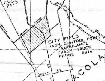
(New page: right|350px|1939 map '''City Field''', sometimes called '''Old Corry Field''', was an outlying landing field (OLF) used by the United States Navy for aviation tr...) |
(No difference)
|
Revision as of 18:12, 28 April 2008
City Field, sometimes called Old Corry Field, was an outlying landing field (OLF) used by the United States Navy for aviation training purposes in connection with NAS Pensacola. The field was located north of downtown Pensacola, near the present-day Woodland Heights neighborhood.
The field was granted to the Navy by the Escambia County Commission in 1922 under a no-cost, five-year lease. The Navy named the field in honour of Lieutenant Commander William M. Corry. In 1927, at the end of the lease period, the Navy determined the field to be too small, and acquired a new site from Escambia County, located about three miles north of NAS Pensacola. Thereafter the Corry Field name shifted to that facility, and the original field entered use as an outlying landing field under the name "City Field". The Navy continued to use the field until the early 1940s, after which time residential and commercial development overtook it.
The field's approximate location has been overlaid on a present-day map below:
<googlemap lat="30.449784" lon="-87.218614" zoom="15" width="500" height="500" selector="yes">
- 758BC5 (#C9D3FF)
30.449451, -87.225823 30.456332, -87.214794 30.448674, -87.212949 30.443235, -87.222562 30.449414, -87.225738 </googlemap>
Other images
Aerial view from December 2, 1940. The north-south road bisecting the field is present-day Davis Highway.


